
Thank you for supporting this site ❤️
Make a donation
Make a donation
Gear up for your next adventure:
As an Amazon Associate, this site earns from qualifying purchases at no extra cost to you.
Cañivi topographic map
Click on the map to display elevation.
Thank you for supporting this site ❤️
Make a donation
Make a donation
Gear up for your next adventure:
As an Amazon Associate, this site earns from qualifying purchases at no extra cost to you.
About this map
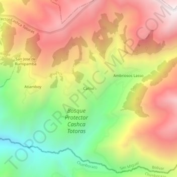
Name: Cañivi topographic map, elevation, terrain.
Location: Cañivi, Santiago, San Miguel, Bolívar, Ecuador (-1.76314 -78.94969 -1.72314 -78.90969)
Average elevation: 3,624 m
Minimum elevation: 2,893 m
Maximum elevation: 4,303 m
Thank you for supporting this site ❤️
Make a donation
Make a donation
Gear up for your next adventure:
As an Amazon Associate, this site earns from qualifying purchases at no extra cost to you.