Geolocate

Mabunga topographic map

Click on the map to display elevation.

About this map

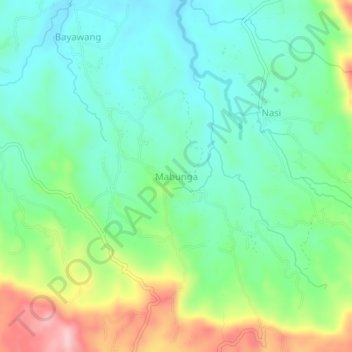
Name: Mabunga topographic map, elevation, terrain.

Location: Mabunga, Rosario, Batangas, Calabarzon, Philippines (13.74920 121.27924 13.78920 121.31924)

Average elevation: 151 m

Minimum elevation: 87 m

Maximum elevation: 290 m

Other topographic maps

Click on a map to view its topography, its elevation and its terrain.

Pinagsibaan

Philippines > Batangas > Rosario

Average elevation: 57 m

Gear up for your next adventure:

🧳Compression Sacks - Maximize space in your backpack by shrinking gear
🥾Trekking Boots - Durable boots for long-distance trekking
🎒Fully Waterproof Backpack - Total protection for photography gear and electronics
🧥Waterproof Jacket - Lightweight rain jackets for hiking and outdoor activities
🧤Rechargeable Heated Gloves - Extreme warmth for Canadian winter expeditions

As an Amazon Associate, this site earns from qualifying purchases at no extra cost to you.