
Arel topographic map
Interactive map
Click on the map to display elevation.
About this map
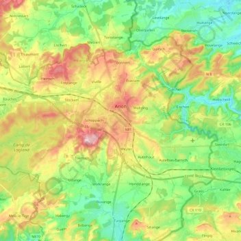
Name: Arel topographic map, elevation, terrain.
Location: Arel, Luxemburg, Wallonien, Belgien (49.62188 5.67846 49.72723 5.91068)
Average elevation: 347 m
Minimum elevation: 267 m
Maximum elevation: 468 m
Die Stadt liegt auf einer Anhöhe, 404 m ü. M. am Ufer der Semois (deutsch Setzbach oder Sesbach), nahe der Grenze zum Großherzogtum Luxemburg, etwa 190 km südöstlich von Brüssel.
Other topographic maps
Click on a map to view its topography, its elevation and its terrain.