
Make a donation
Gear up for your next adventure:
As an Amazon Associate, this site earns from qualifying purchases at no extra cost to you.
Baar topographic map
Click on the map to display elevation.
Make a donation
Gear up for your next adventure:
As an Amazon Associate, this site earns from qualifying purchases at no extra cost to you.
About this map
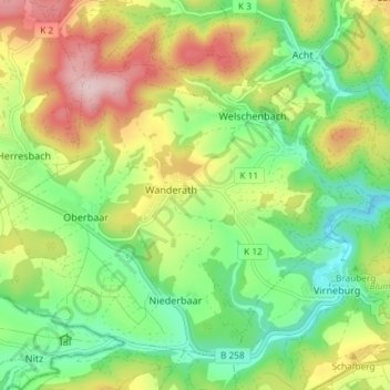
Name: Baar topographic map, elevation, terrain.
Average elevation: 487 m
Minimum elevation: 375 m
Maximum elevation: 656 m
Make a donation
Gear up for your next adventure:
As an Amazon Associate, this site earns from qualifying purchases at no extra cost to you.
Other topographic maps
Click on a map to view its topography, its elevation and its terrain.
Hausen
Deutschland > Rheinland-Pfalz > Landkreis Mayen-Koblenz > Mayen
Der Ursprung der katholischen Kirche St. Silvester ist Ende des 12. Jahrhunderts anzunehmen; es war eine zweischiffige Pfeilerbasilika mit halbrundem Chor. Ein Pfarrer von „Huyssen“ ist um 1330 erstmals genannt. In der Zeit um 1330 bis 1340 wurde der romanische Chor niedergelegt, das Kirchenschiff…
Average elevation: 242 m