
Make a donation
Gear up for your next adventure:
As an Amazon Associate, this site earns from qualifying purchases at no extra cost to you.
Neuhemsbach topographic map
Click on the map to display elevation.
Make a donation
Gear up for your next adventure:
As an Amazon Associate, this site earns from qualifying purchases at no extra cost to you.
Neuhemsbach
Aus dem 14. Jahrhundert stammt der auf der Höhe „Spitzer Hübel“ gelegene Rest der Anselburg.
Make a donation
Gear up for your next adventure:
As an Amazon Associate, this site earns from qualifying purchases at no extra cost to you.
About this map
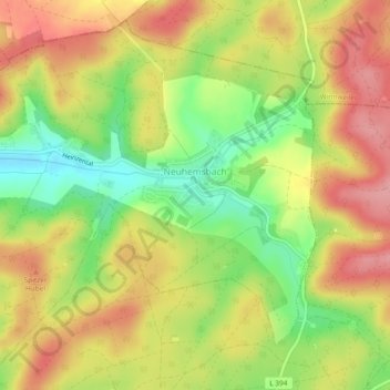
Name: Neuhemsbach topographic map, elevation, terrain.
Average elevation: 323 m
Minimum elevation: 262 m
Maximum elevation: 375 m
Make a donation
Gear up for your next adventure:
As an Amazon Associate, this site earns from qualifying purchases at no extra cost to you.
Other topographic maps
Click on a map to view its topography, its elevation and its terrain.
Schweinstal
Deutschland > Rheinland-Pfalz > Landkreis Kaiserslautern > Krickenbach
Average elevation: 349 m
Althütterhof
Deutschland > Rheinland-Pfalz > Landkreis Kaiserslautern > Otterberg
Average elevation: 307 m
Stüterhof
Deutschland > Rheinland-Pfalz > Landkreis Kaiserslautern > Waldleiningen
Average elevation: 428 m
Kreuzberg
Deutschland > Rheinland-Pfalz > Landkreis Kaiserslautern > Oberarnbach
Average elevation: 399 m
Make a donation
Gear up for your next adventure:
As an Amazon Associate, this site earns from qualifying purchases at no extra cost to you.
Lauerhof
Deutschland > Rheinland-Pfalz > Landkreis Kaiserslautern > Otterberg
Average elevation: 296 m
Weinbrunnerhof
Deutschland > Rheinland-Pfalz > Landkreis Kaiserslautern > Otterberg > Weinbrunnerhof
Average elevation: 319 m
Hirschhorner Bordenmühle
Deutschland > Rheinland-Pfalz > Landkreis Kaiserslautern > Sulzbachtal > Hirschhorner Bordenmühle
Average elevation: 262 m
Make a donation
Gear up for your next adventure:
As an Amazon Associate, this site earns from qualifying purchases at no extra cost to you.
Kaulbach
Deutschland > Rheinland-Pfalz > Landkreis Kaiserslautern > Reichenbach-Steegen
Average elevation: 328 m