
Buffalo topographic map
Interactive map
Click on the map to display elevation.
About this map
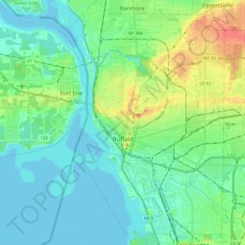
Name: Buffalo topographic map, elevation, terrain.
Location: Buffalo, Erie County, New York, United States (42.82601 -78.92236 42.96645 -78.79512)
Average elevation: 185 m
Minimum elevation: 172 m
Maximum elevation: 220 m
The Buffalo metropolitan area is on the Erie/Ontario Lake Plain of the Eastern Great Lakes Lowlands, a narrow plain extending east to Utica, New York. The city is generally flat, except for elevation changes in the University Heights and Fruit Belt neighborhoods. The Southtowns are hillier, leading to the Cattaraugus Hills in the Appalachian Upland. Several types of shale, limestone and lagerstätten are prevalent in Buffalo and its surrounding area, lining their stream beds.
Other topographic maps
Click on a map to view its topography, its elevation and its terrain.
Town of Orchard Park
United States > New York > Erie County
Town of Orchard Park, Erie County, New York, 14127, United States
Average elevation: 272 m
Getzville
United States > New York > Erie County > Town of Amherst
Getzville, Town of Amherst, Erie County, New York, 14068, United States
Average elevation: 179 m
Town of Amherst
United States > New York > Erie County
Town of Amherst, Erie County, New York, United States
Average elevation: 184 m
Onondaga Escarpment
United States > New York > Erie County > Village of Akron
Onondaga Escarpment, Village of Akron, Town of Newstead, Erie County, New York, 14001, United States
Average elevation: 235 m
Town of Cheektowaga
United States > New York > Erie County
Town of Cheektowaga, Erie County, New York, United States
Average elevation: 201 m
Town of Colden
United States > New York > Erie County
Town of Colden, Erie County, New York, 14033, United States
Average elevation: 412 m
Sandy Beach
United States > New York > Erie County > Town of Grand Island
Sandy Beach, Town of Grand Island, Erie County, New York, 14304, United States
Average elevation: 175 m
East Aurora
United States > New York > Erie County
East Aurora, Town of Aurora, Erie County, New York, 14052, United States
Average elevation: 283 m
Tonawanda
United States > New York > Erie County > Tonawanda
Tonawanda, Erie County, New York, United States
Average elevation: 180 m
Village of Orchard Park
United States > New York > Erie County > Town of Orchard Park
Village of Orchard Park, Town of Orchard Park, Aurora, Erie County, New York, 14127, United States
Average elevation: 262 m