
Mangaluru topographic map
Click on the map to display elevation.
Mangaluru
Mangalore is one of the fastest developing cities in India. The Dakshina Kannada district with its administrative headquarters at Mangalore has the highest Per Capita Income and Gross State Domestic Product in Karnataka, after Bangalore. Mangalore is a commercial, industrial, business, educational, healthcare, and startup hub. The city's international airport is the second-largest and second-busiest airport in Karnataka. Mangalore City Corporation is responsible for the civic administration which manages the 60 wards of the city. Its landscape is characterised by rolling hills, coconut palms, rivers, and hard laterite soil. It is the richest city in Karnataka after Bangalore. Mangalore ranked India's 13th place in top business destination and in Karnataka it is second after Bangalore. Mangalore is growing like Dubai of South India in terms of highrise buildings & skyscrapers. The city houses some of the tallest buildings in South India. India's first 3D planetarium with 8K resolution display is located in the city. Mangalore is included as one of the cities in the Smart Cities Mission list and is among the 100 smart cities to be developed in India. It has an average elevation of 22 m (72 ft) above mean sea level. It has a tropical monsoon climate and is under the influence of the southwest monsoon. In 2017, Mangalore was ranked the 48th best city in the world to live in by a US survey, and the only Indian city in the top 50. It has its own International Airport which is around 15 km from the city centre.
About this map
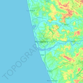
Name: Mangaluru topographic map, elevation, terrain.
Average elevation: 25 m
Minimum elevation: -2 m
Maximum elevation: 205 m
Other topographic maps
Click on a map to view its topography, its elevation and its terrain.