Geolocate

Taviano topographic map

Click on the map to display elevation.

About this map

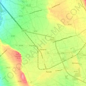
Name: Taviano topographic map, elevation, terrain.

Location: Taviano, Lecce, Apulia, Italy (39.96526 18.01195 40.01344 18.11431)

Average elevation: 49 m

Minimum elevation: 6 m

Maximum elevation: 97 m

Other topographic maps

Click on a map to view its topography, its elevation and its terrain.

Santa Maria al Bagno

Italy > Apulia > Lecce > Nardò

Average elevation: 32 m

Torre Chianca

Italy > Apulia > Lecce > Lecce

Average elevation: 2 m

Madonna di Roca Vecchia

Italy > Apulia > Lecce > Roca

Average elevation: 6 m

Gear up for your next adventure:

🦶Hiking Shoe Insoles - Added support for high arches and long days on feet
🧭GPS Tracker - Track your location in remote areas safely
Camping Essentials - All-in-one gear for a comfortable camping trip
🛶Kayak Dry Bag - Waterproof storage for kayaking adventures
🥾Hiking Boots - Sturdy boots providing ankle support and traction on rugged trails

As an Amazon Associate, this site earns from qualifying purchases at no extra cost to you.