Geolocate

Carbondale topographic map

Click on the map to display elevation.

About this map

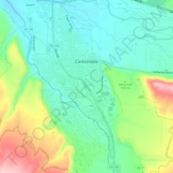
Name: Carbondale topographic map, elevation, terrain.

Location: Carbondale, Garfield County, Colorado, United States (39.37429 -107.22789 39.41493 -107.20030)

Average elevation: 1,919 m

Minimum elevation: 1,854 m

Maximum elevation: 2,059 m

Other topographic maps

Click on a map to view its topography, its elevation and its terrain.

Coulter Mesa

United States > Colorado > Garfield County

Average elevation: 2,690 m

Catherine

United States > Colorado > Garfield County

Average elevation: 2,020 m

Gear up for your next adventure:

🕯️Camping Lantern - Illuminates your entire campsite with high-efficiency LEDs
🔋Solar Power Bank - Keep your GPS and devices charged during long outdoor trips
🧴Outdoor Sunscreen - High SPF protection for high-altitude UV exposure
🛶Canoe Life Vest - Safety vest for water sports
🩹Moleskin Blister Pads - Direct protection for painful foot pressure points

As an Amazon Associate, this site earns from qualifying purchases at no extra cost to you.