Geolocate

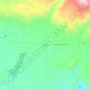
Onalaska topographic map

Click on the map to display elevation.

About this map
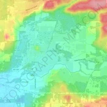
Name: Onalaska topographic map, elevation, terrain.

Location: Onalaska, Lewis County, Washington, 98570, United States (46.56826 -122.73787 46.58892 -122.68281)

Average elevation: 173 m

Minimum elevation: 133 m

Maximum elevation: 249 m

Other topographic maps

Click on a map to view its topography, its elevation and its terrain.
Randle

United States > Washington > Lewis County

Average elevation: 378 m

Cinebar

United States > Washington > Lewis County

Average elevation: 308 m

The Rockies

United States > Washington > Lewis County

Average elevation: 1,012 m

Silver Falls

United States > Washington > Lewis County

Average elevation: 847 m

Angry Mountain

United States > Washington > Lewis County

Average elevation: 1,401 m

Onalaska

United States > Washington > Lewis County

Average elevation: 170 m

Packwood

United States > Washington > Lewis County

Average elevation: 379 m

Adna

United States > Washington > Lewis County

Average elevation: 82 m

Mayfield

United States > Washington > Lewis County

Average elevation: 223 m

Bunker

United States > Washington > Lewis County

Average elevation: 101 m

Ceres

United States > Washington > Lewis County

Average elevation: 123 m

Glenoma

United States > Washington > Lewis County

Average elevation: 354 m

Randle

United States > Washington > Lewis County

Average elevation: 378 m

Ham Hill

United States > Washington > Lewis County > Centralia

Average elevation: 101 m

Gear up for your next adventure:

💧Hydration Bladder - Hands-free hydration solution for long treks
🥾Mountaineering Boots - Supportive boots for climbing and high-altitude hiking
🧤Insulated Winter Gloves - Heavy-duty protection for sub-zero Canadian adventures
🛁Quick-Dry Microfiber Towel - Space-saving towel that dries rapidly on the move
🥾Approach Boots - Comfortable boots for hiking and climbing approaches

As an Amazon Associate, this site earns from qualifying purchases at no extra cost to you.