Geolocate

Tulsipur topographic map

Click on the map to display elevation.

About this map

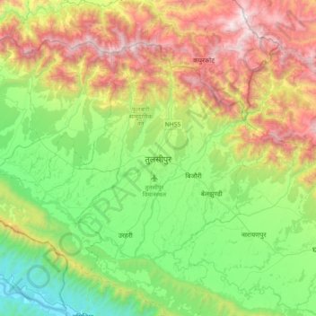
Name: Tulsipur topographic map, elevation, terrain.

Location: Tulsipur, Dang, Lumbini Province, 22412, Nepal (27.97121 82.13831 28.29121 82.45831)

Average elevation: 886 m

Minimum elevation: 202 m

Maximum elevation: 2,088 m

Other topographic maps

Click on a map to view its topography, its elevation and its terrain.

Rapti River

Nepal > Lumbini Province > Dang

Average elevation: 564 m

Gear up for your next adventure:

👟Sport Hiking Sandals - Breathable footwear for water crossings and camp rest
🥾All-Terrain Hiking Boots - Versatile boots for varied hiking conditions
🥾Trekking Boots - Durable boots for long-distance trekking
🔦LED Headtorch - Bright and durable light for night activities
🔭Compact Monocular - One-handed bird watching and trail spotting

As an Amazon Associate, this site earns from qualifying purchases at no extra cost to you.