Geolocate

Port Arthur topographic map

Click on the map to display elevation.

About this map
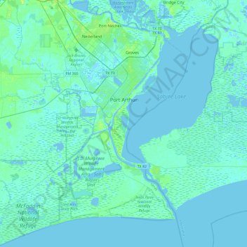
Name: Port Arthur topographic map, elevation, terrain.

Location: Port Arthur, Jefferson County, Texas, United States (29.63312 -94.10662 30.03235 -93.81135)

Average elevation: 2 m

Minimum elevation: -5 m

Maximum elevation: 14 m

Other topographic maps

Click on a map to view its topography, its elevation and its terrain.

Hamshire

United States > Texas > Jefferson County

Average elevation: 6 m

Beaumont

United States > Texas > Jefferson County > Beaumont

Average elevation: 6 m

Zummo

United States > Texas > Jefferson County > Beaumont

Average elevation: 6 m

Gear up for your next adventure:

💧Reusable Water Bottle - Durable water bottles for hydration on trails
🔋Solar Power Bank - Keep your GPS and devices charged during long outdoor trips
🧼Biodegradable Camp Soap - Environmentally friendly cleaning for gear and body
🔪Outdoor Multitool - Versatile tool for repairs and food prep in the wild
🔦LED Headtorch - Bright and durable light for night activities

As an Amazon Associate, this site earns from qualifying purchases at no extra cost to you.