Geolocate

Pager topographic map

Click on the map to display elevation.

About this map

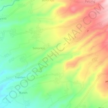
Name: Pager topographic map, elevation, terrain.

Location: Pager, Magelang, Central Java, Java, Indonesia (-7.52370 110.29171 -7.48370 110.33171)

Average elevation: 583 m

Minimum elevation: 442 m

Maximum elevation: 758 m

Other topographic maps

Click on a map to view its topography, its elevation and its terrain.

Salam

Indonesia > Central Java > Magelang

Average elevation: 284 m

Adikarto

Indonesia > Central Java > Magelang > Tanjung

Average elevation: 245 m

Sungai Progo

Indonesia > Central Java > Magelang > Mungkid

Average elevation: 232 m

Dukun

Indonesia > Central Java > Magelang

Average elevation: 911 m

Ngluwar

Indonesia > Central Java > Magelang

Average elevation: 242 m

Srumbung

Indonesia > Central Java > Magelang

Average elevation: 764 m

Sawangan

Indonesia > Central Java > Magelang

Average elevation: 1,299 m

Muntilan

Indonesia > Central Java > Magelang

Average elevation: 296 m

Gear up for your next adventure:

Camping Essentials - All-in-one gear for a comfortable camping trip
Backpacking Tent - Lightweight tent for long-distance hiking trips
🧴Waterproofing Spray - Restore the DWR coating on jackets and tents
💧Collapsible Water Bottle - Space-saving water bottle for outdoor activities
🚲Bike Repair Kit - Essential tools for on-trail mechanical issues

As an Amazon Associate, this site earns from qualifying purchases at no extra cost to you.