Geolocate

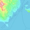
Taba Heights topographic map

Click on the map to display elevation.

About this map

Name: Taba Heights topographic map, elevation, terrain.

Location: Taba Heights, South Sinai, Egypt (29.37000 34.77953 29.41000 34.81953)

Average elevation: 111 m

Minimum elevation: 0 m

Maximum elevation: 682 m

Other topographic maps

Click on a map to view its topography, its elevation and its terrain.
Ras Sudr

Egypt > South Sinai

Average elevation: 17 m

Abu Galum Protectorate

Egypt > South Sinai

Average elevation: 632 m

Ras Muhammad National Park

Egypt > South Sinai

Average elevation: 112 m

Ras Sudr

Egypt > South Sinai

Average elevation: 17 m

Al Tour City

Egypt > South Sinai

Average elevation: 50 m

Wadi Khuraytah

Egypt > South Sinai > Saint Catherine

Average elevation: 1,323 m

Gear up for your next adventure:

🪑Insulated Seat Pad - Protect your seat from cold rocks and wet logs
⛺Backpacking Tent - Lightweight tent for long-distance hiking trips
🔦LED Headtorch - Bright and durable light for night activities
🧦Thermal Socks - Warm socks for winter hiking or camping
🥾Mountaineering Boots - Supportive boots for climbing and high-altitude hiking

As an Amazon Associate, this site earns from qualifying purchases at no extra cost to you.