
Make a donation
Gear up for your next adventure:
As an Amazon Associate, this site earns from qualifying purchases at no extra cost to you.
Bernterode topographic map
Click on the map to display elevation.
Make a donation
Gear up for your next adventure:
As an Amazon Associate, this site earns from qualifying purchases at no extra cost to you.
Bernterode
Bernterode liegt im Obereichsfeld ungefähr acht Kilometer südlich der Kreisstadt Heilbad Heiligenstadt. Der Ort befindet sich in einem Talkessel südlich der Kalteneberschen Höhe (mit dem Ebersberg: 494 m) umgeben von den Bergkuppen Hopfgarten (480 m) im Südwesten, Eichenberg (445 m) im Nordwesten, Kirchberg (454 m) im Osten und Heuberg (453 m) im Südosten. Weitere Nachbarorte sind Martinfeld im Südosten, und Krombach im Südwesten.
Make a donation
Gear up for your next adventure:
As an Amazon Associate, this site earns from qualifying purchases at no extra cost to you.
About this map
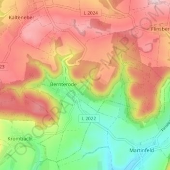
Name: Bernterode topographic map, elevation, terrain.
Average elevation: 399 m
Minimum elevation: 265 m
Maximum elevation: 517 m
Make a donation
Gear up for your next adventure:
As an Amazon Associate, this site earns from qualifying purchases at no extra cost to you.
Other topographic maps
Click on a map to view its topography, its elevation and its terrain.
Flinsberg
Deutschland > Thüringen > Landkreis Eichsfeld > Heilbad Heiligenstadt > Flinsberg
Average elevation: 445 m