
L'Oratoire topographic map
Interactive map
Click on the map to display elevation.
About this map
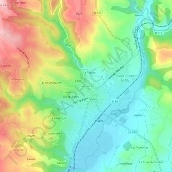
Name: L'Oratoire topographic map, elevation, terrain.
Average elevation: 334 m
Minimum elevation: 245 m
Maximum elevation: 479 m
Other topographic maps
Click on a map to view its topography, its elevation and its terrain.
Lacoste
France > Auvergne-Rhône-Alpes > Cantal > Maurs
Lacoste, Maurs, Aurillac, Cantal, Auvergne-Rhône-Alpes, France métropolitaine, 15600, France
Average elevation: 332 m
Raynou
France > Auvergne-Rhône-Alpes > Cantal > Maurs
Raynou, Maurs, Aurillac, Cantal, Auvergne-Rhône-Alpes, France métropolitaine, 15600, France
Average elevation: 313 m