
Saint-Mathieu-de-Rioux topographic map
Click on the map to display elevation.
About this map
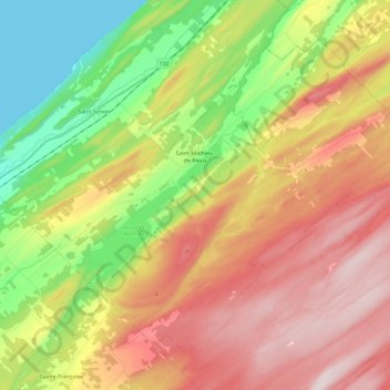
Name: Saint-Mathieu-de-Rioux topographic map, elevation, terrain.
Average elevation: 230 m
Minimum elevation: 0 m
Maximum elevation: 479 m
Les Basques trails, hiking, mountain biking, running and outdoor activities
Other topographic maps
Click on a map to view its topography, its elevation and its terrain.
Rivière-Trois-Pistoles
Canada > Quebec > Les Basques > Notre-Dame-des-Neiges > Rivière-Trois-Pistoles
Average elevation: 50 m