
Make a donation
Gear up for your next adventure:
As an Amazon Associate, this site earns from qualifying purchases at no extra cost to you.
Valencia topographic map
Click on the map to display elevation.
Make a donation
Gear up for your next adventure:
As an Amazon Associate, this site earns from qualifying purchases at no extra cost to you.
About this map
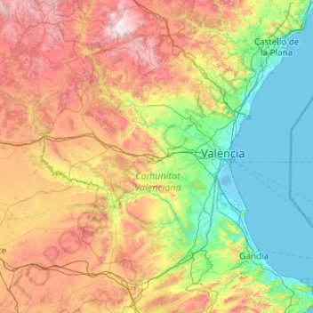
Name: Valencia topographic map, elevation, terrain.
Location: Valencia, Valencianische Gemeinschaft, Spanien (38.68655 -1.52894 40.21168 -0.02472)
Average elevation: 570 m
Minimum elevation: -4 m
Maximum elevation: 1,996 m
Make a donation
Gear up for your next adventure:
As an Amazon Associate, this site earns from qualifying purchases at no extra cost to you.
Other topographic maps
Click on a map to view its topography, its elevation and its terrain.
Losilla
Spanien > Valencianische Gemeinschaft > La Serranía > Aras de los Olmos
Average elevation: 1,139 m
Make a donation
Gear up for your next adventure:
As an Amazon Associate, this site earns from qualifying purchases at no extra cost to you.
Platja del Port de Sagunt
Spanien > Valencianische Gemeinschaft > Sagunt / Sagunto
Average elevation: 3 m
Make a donation
Gear up for your next adventure:
As an Amazon Associate, this site earns from qualifying purchases at no extra cost to you.
Hurchillo
Spanien > Valencianische Gemeinschaft > el Baix Segura / La Vega Baja del Segura > Orihuela
Average elevation: 62 m
Rambla
Spanien > Valencianische Gemeinschaft > el Baix Segura / La Vega Baja del Segura > Albatera
Average elevation: 15 m
Make a donation
Gear up for your next adventure:
As an Amazon Associate, this site earns from qualifying purchases at no extra cost to you.
Valencia
Spanien > Valencianische Gemeinschaft > Valencia > Valencia
Die Fallas beginnen mit Anfang März und erreichen am 15.–19. März ihren Höhepunkt. Sie werden mit Umzügen durch die Stadtviertel in traditioneller Tracht, Festessen und Feuerwerken gefeiert. Es gibt zwei verschiedene Kategorien von Feuerwerken: das eine sind die mascletàs die täglich um 14 Uhr in allen…
Average elevation: 44 m
Cabo de la Nao
Spanien > Valencianische Gemeinschaft > Alicante > Xàbia / Jávea
Average elevation: 32 m
Sant Jordi / San Jorge
Spanien > Valencianische Gemeinschaft > Castelló / Castellón > Sant Jordi / San Jorge > Sant Jordi / San Jorge
Average elevation: 178 m
Make a donation
Gear up for your next adventure:
As an Amazon Associate, this site earns from qualifying purchases at no extra cost to you.
Vila-real
Spanien > Valencianische Gemeinschaft > Castelló / Castellón > Vila-real > Vila-real
Average elevation: 42 m