
Thank you for supporting this site ❤️
Make a donation
Make a donation
Gear up for your next adventure:
As an Amazon Associate, this site earns from qualifying purchases at no extra cost to you.
Socorro topographic map
Click on the map to display elevation.
Thank you for supporting this site ❤️
Make a donation
Make a donation
Gear up for your next adventure:
As an Amazon Associate, this site earns from qualifying purchases at no extra cost to you.
About this map
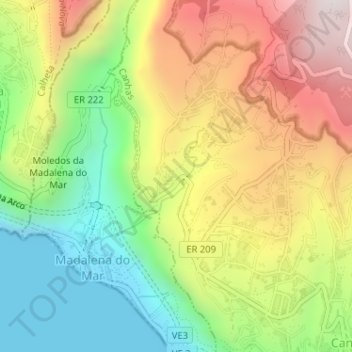
Name: Socorro topographic map, elevation, terrain.
Location: Socorro, Canhas, Ponta do Sol, Madeira, 9360-402, Portugal (32.69781 -17.13670 32.71781 -17.11670)
Average elevation: 413 m
Minimum elevation: 0 m
Maximum elevation: 915 m
Thank you for supporting this site ❤️
Make a donation
Make a donation
Gear up for your next adventure:
As an Amazon Associate, this site earns from qualifying purchases at no extra cost to you.