
Make a donation
Gear up for your next adventure:
As an Amazon Associate, this site earns from qualifying purchases at no extra cost to you.
Gonzerath topographic map
Click on the map to display elevation.
Make a donation
Gear up for your next adventure:
As an Amazon Associate, this site earns from qualifying purchases at no extra cost to you.
About this map
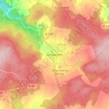
Name: Gonzerath topographic map, elevation, terrain.
Average elevation: 503 m
Minimum elevation: 340 m
Maximum elevation: 583 m
Make a donation
Gear up for your next adventure:
As an Amazon Associate, this site earns from qualifying purchases at no extra cost to you.
Other topographic maps
Click on a map to view its topography, its elevation and its terrain.
Merscheid
Deutschland > Rheinland-Pfalz > Landkreis Bernkastel-Wittlich > Morbach > Merscheid
Average elevation: 458 m
Wolzburg
Deutschland > Rheinland-Pfalz > Landkreis Bernkastel-Wittlich > Morbach
Average elevation: 558 m
Hoxel
Deutschland > Rheinland-Pfalz > Landkreis Bernkastel-Wittlich > Morbach
Average elevation: 514 m
Heinzerath
Deutschland > Rheinland-Pfalz > Landkreis Bernkastel-Wittlich > Morbach
Average elevation: 496 m
Make a donation
Gear up for your next adventure:
As an Amazon Associate, this site earns from qualifying purchases at no extra cost to you.
Gonzerath
Deutschland > Rheinland-Pfalz > Landkreis Bernkastel-Wittlich > Morbach > Gonzerath
Average elevation: 504 m