Geolocate

Hammar topographic map

Click on the map to display elevation.

About this map

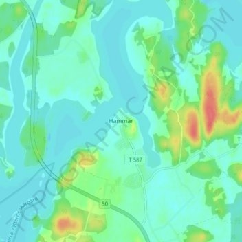
Name: Hammar topographic map, elevation, terrain.

Location: Hammar, Askersunds kommun, Örebro County, 696 94, Sweden (58.80074 14.93674 58.84074 14.97674)

Average elevation: 97 m

Minimum elevation: 85 m

Maximum elevation: 139 m

Other topographic maps

Click on a map to view its topography, its elevation and its terrain.

Hallsbergs kommun

Sweden > Örebro County

Average elevation: 92 m

Malingsbo-Kloten

Sweden > Örebro County

Average elevation: 274 m

Laxå kommun

Sweden > Örebro County

Average elevation: 116 m

Örebro kommun

Sweden > Örebro County

Average elevation: 64 m

Örebro kommun

Sweden > Örebro County

Average elevation: 64 m

Gear up for your next adventure:

🥾Hiking Shorts - Breathable shorts suitable for summer hikes
🥾Trail Running Boots - Durable shoes designed for trail running
🧴First Aid Kit - Essential first aid supplies for outdoor emergencies
🥾Waterproof Hiking Shoes - Durable shoes for wet and rugged trails
🔭Compact Monocular - One-handed bird watching and trail spotting

As an Amazon Associate, this site earns from qualifying purchases at no extra cost to you.