
Make a donation
Gear up for your next adventure:
As an Amazon Associate, this site earns from qualifying purchases at no extra cost to you.
Cross River State topographic map
Click on the map to display elevation.
Make a donation
Gear up for your next adventure:
As an Amazon Associate, this site earns from qualifying purchases at no extra cost to you.
Cross River State
Like few other Nigerian states, the climate of Cross River state is tropical. Not only this, the state is characterised with relative humidity. The average temperature of the state is between 150C and 300C. However, this climatic condition is different in locations within the Cross River state such as the high plateau of Obudu, which has a record of a fall in temperature between 40C and 100C, as a result of the high altitude of this area. The capital city of the State, Calabar, has a significant record of rainfall within the year, while the dry season has less significant effect in the state due to the depth of rainfall experienced. Based on the records presented by the Climate Data of the state, the annual rainfall of Cross River state is 3306mm| 130.2 inch.
Make a donation
Gear up for your next adventure:
As an Amazon Associate, this site earns from qualifying purchases at no extra cost to you.
About this map
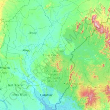
Name: Cross River State topographic map, elevation, terrain.
Location: Cross River State, Nigeria (4.67444 7.84087 6.89641 9.47441)
Average elevation: 173 m
Minimum elevation: -1 m
Maximum elevation: 1,849 m
Make a donation
Gear up for your next adventure:
As an Amazon Associate, this site earns from qualifying purchases at no extra cost to you.
Other topographic maps
Click on a map to view its topography, its elevation and its terrain.
Ibadan
Nigeria > Oyo State > Ibadan South West
Ibadan, coined from the phrase "Eba-Odan", which literally means 'by the edge of the meadow', came into existence in 1829, during a period of turmoil that characterized Yorubaland at the time. It was in this period that many old Yoruba cities such as old Oyo (Oyo-ile), Ijaye and Owu disappeared, and newer ones…
Average elevation: 191 m
Make a donation
Gear up for your next adventure:
As an Amazon Associate, this site earns from qualifying purchases at no extra cost to you.
Make a donation
Gear up for your next adventure:
As an Amazon Associate, this site earns from qualifying purchases at no extra cost to you.
Make a donation
Gear up for your next adventure:
As an Amazon Associate, this site earns from qualifying purchases at no extra cost to you.
Make a donation
Gear up for your next adventure:
As an Amazon Associate, this site earns from qualifying purchases at no extra cost to you.
Make a donation
Gear up for your next adventure:
As an Amazon Associate, this site earns from qualifying purchases at no extra cost to you.
Make a donation
Gear up for your next adventure:
As an Amazon Associate, this site earns from qualifying purchases at no extra cost to you.
Make a donation
Gear up for your next adventure:
As an Amazon Associate, this site earns from qualifying purchases at no extra cost to you.
Make a donation
Gear up for your next adventure:
As an Amazon Associate, this site earns from qualifying purchases at no extra cost to you.