
Thank you for supporting this site ❤️
Make a donation
Make a donation
Gear up for your next adventure:
As an Amazon Associate, this site earns from qualifying purchases at no extra cost to you.
Kimanyi A topographic map
Click on the map to display elevation.
Thank you for supporting this site ❤️
Make a donation
Make a donation
Gear up for your next adventure:
As an Amazon Associate, this site earns from qualifying purchases at no extra cost to you.
About this map
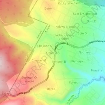
Name: Kimanyi A topographic map, elevation, terrain.
Location: Kimanyi A, Molo ward, Molo, Nakuru, Rift Valley, Kenya (-0.22880 35.76203 -0.18880 35.80203)
Average elevation: 2,195 m
Minimum elevation: 2,022 m
Maximum elevation: 2,379 m
Thank you for supporting this site ❤️
Make a donation
Make a donation
Gear up for your next adventure:
As an Amazon Associate, this site earns from qualifying purchases at no extra cost to you.