Geolocate

Policarpa topographic map

Click on the map to display elevation.

About this map

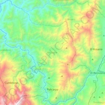
Name: Policarpa topographic map, elevation, terrain.

Location: Policarpa, La Cordillera, Nariño, RAP Pacífico, Colombia (1.58431 -77.62253 1.88380 -77.35012)

Average elevation: 1,128 m

Minimum elevation: 190 m

Maximum elevation: 3,490 m

Other topographic maps

Click on a map to view its topography, its elevation and its terrain.

Catambuco

Colombia > Nariño > Pasto

Average elevation: 2,874 m

Isla de la Corota

Colombia > Nariño > Pasto

Average elevation: 2,786 m

Río Patía

Colombia > Nariño > Cumbitara

Average elevation: 568 m

Gear up for your next adventure:

🧣Evaporative Cooling Towel - Beat the heat during intense summer climbs
🥾Trekking Poles - Adjustable trekking poles to reduce knee stress and improve stability
🥾Hiking Boots - Sturdy boots providing ankle support and traction on rugged trails
🚲MTB Frame Bag - Carry tools and maps directly on your bicycle frame
🧢Outdoor Cap - Protective cap for sun and rain during hikes

As an Amazon Associate, this site earns from qualifying purchases at no extra cost to you.