
Make a donation
Gear up for your next adventure:
As an Amazon Associate, this site earns from qualifying purchases at no extra cost to you.
Berlin topographic map
Click on the map to display elevation.
Make a donation
Gear up for your next adventure:
As an Amazon Associate, this site earns from qualifying purchases at no extra cost to you.
Berlin
Berlin is located at 39°55′17″N 78°57′00″W / 39.9213°N 78.9501°W / 39.9213; -78.9501, approximately 11 miles (18 km) southeast of Somerset and approximately 63 miles (101 km) south-southwest of Altoona. According to the United States Census Bureau, the borough has a total area of 0.9 square miles (2.3 km2), all land. Berlin has an elevation of 2,323 feet (708 m), the second highest, after only Seven Springs, in Pennsylvania.
Make a donation
Gear up for your next adventure:
As an Amazon Associate, this site earns from qualifying purchases at no extra cost to you.
About this map
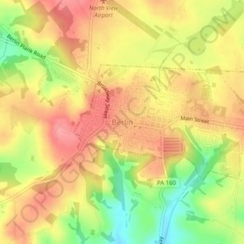
Name: Berlin topographic map, elevation, terrain.
Location: Berlin, Somerset County, Pennsylvania, United States (39.91442 -78.96566 39.92719 -78.93737)
Average elevation: 691 m
Minimum elevation: 634 m
Maximum elevation: 729 m
Make a donation
Gear up for your next adventure:
As an Amazon Associate, this site earns from qualifying purchases at no extra cost to you.
Other topographic maps
Click on a map to view its topography, its elevation and its terrain.
Hollsopple
United States > Pennsylvania > Somerset County > Conemaugh Township
Average elevation: 545 m
Listie
United States > Pennsylvania > Somerset County > Somerset Township > Listie
Average elevation: 682 m
Boynton
United States > Pennsylvania > Somerset County > Elk Lick Township > Boynton
Average elevation: 656 m
Make a donation
Gear up for your next adventure:
As an Amazon Associate, this site earns from qualifying purchases at no extra cost to you.
Kantner
United States > Pennsylvania > Somerset County > Quemahoning Township
Average elevation: 608 m
Bearwallow Mountain
United States > Pennsylvania > Somerset County > Fairhope Township
Average elevation: 660 m
Ralphton
United States > Pennsylvania > Somerset County > Quemahoning Township > Ralphton
Average elevation: 636 m