
Make a donation
Gear up for your next adventure:
As an Amazon Associate, this site earns from qualifying purchases at no extra cost to you.
Hochalmspitze topographic map
Click on the map to display elevation.
Make a donation
Gear up for your next adventure:
As an Amazon Associate, this site earns from qualifying purchases at no extra cost to you.
Hochalmspitze
Die Hochalmspitze (veraltet und ortsunüblich auch Hochalpenspitze) ist mit einer Höhe von 3360 m ü. A. die höchste Erhebung der Ankogelgruppe in den Hohen Tauern. Als Gegenstück zum Glockner wird sie auch „Tauernkönigin“ oder „Tauernfürstin“ genannt. Im Volksmund heißt sie Der Hochalmer. Sie liegt östlich von Mallnitz in Kärnten.
Make a donation
Gear up for your next adventure:
As an Amazon Associate, this site earns from qualifying purchases at no extra cost to you.
About this map
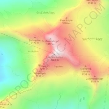
Name: Hochalmspitze topographic map, elevation, terrain.
Average elevation: 2,858 m
Minimum elevation: 2,420 m
Maximum elevation: 3,327 m
Make a donation
Gear up for your next adventure:
As an Amazon Associate, this site earns from qualifying purchases at no extra cost to you.
Other topographic maps
Click on a map to view its topography, its elevation and its terrain.