
Make a donation
Gear up for your next adventure:
As an Amazon Associate, this site earns from qualifying purchases at no extra cost to you.
Monte Caio topographic map
Click on the map to display elevation.
Make a donation
Gear up for your next adventure:
As an Amazon Associate, this site earns from qualifying purchases at no extra cost to you.
About this map
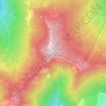
Name: Monte Caio topographic map, elevation, terrain.
Location: Monte Caio, Corniglio, Parma, Emilia-Romagna, Italia (44.46767 10.14940 44.46777 10.14950)
Average elevation: 1,290 m
Minimum elevation: 894 m
Maximum elevation: 1,558 m
Make a donation
Gear up for your next adventure:
As an Amazon Associate, this site earns from qualifying purchases at no extra cost to you.
Other topographic maps
Click on a map to view its topography, its elevation and its terrain.
Lago Santo parmense
Italia > Emilia-Romagna > Parma > Corniglio
Il lago svedese, situato a 1.506 metri d'altitudine nel comune di Corniglio, si trova nella parte occidentale del Parco nazionale dell'Appennino Tosco-Emiliano. È sormontato poco più a sud dal monte Marmagna e dal crinale appenninico che divide la provincia di Parma da quella di Massa Carrara.
Average elevation: 1,493 m