Geolocate

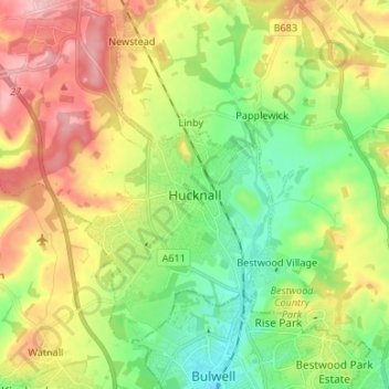
Hucknall topographic map

Click on the map to display elevation.

Hucknall

Hucknall Airfield, built in 1916, became RAF Hucknall. From 1927, Rolls-Royce began using the airfield for flight tests. During World War II, the aerodrome at Hucknall launched the first flight of a P-51 Mustang fitted with a Rolls-Royce Merlin Engine. The Merlin, replacing the earlier Allison V-1710 engine, allowed the Mustang air frame to reach its full potential and achieve spectacular high-altitude performance.

Wikipedia (CC-BY-SA 3.0)

About this map

Name: Hucknall topographic map, elevation, terrain.

Location: Hucknall, Ashfield, Nottinghamshire, England, NG15 7BA, United Kingdom (52.99836 -1.24354 53.07836 -1.16354)

Average elevation: 104 m

Minimum elevation: 44 m

Maximum elevation: 186 m

Gear up for your next adventure:

Lightweight Backpacking Tent - Compact tent for efficient hiking trips
🥾Mountaineering Boots - Supportive boots for climbing and high-altitude hiking
🥾Hiking Shorts - Breathable shorts suitable for summer hikes
🦟Insect Repellent - Keep mosquitoes and black flies away in wooded areas
💡Compact LED Flashlight - Powerful and portable flashlight for outdoor use

As an Amazon Associate, this site earns from qualifying purchases at no extra cost to you.