Geolocate

Cipanas topographic map

Click on the map to display elevation.

About this map

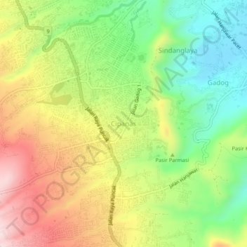
Name: Cipanas topographic map, elevation, terrain.

Location: Cipanas, Cianjur, West Java, Java, 43253, Indonesia (-6.75885 107.02872 -6.71885 107.06872)

Average elevation: 1,057 m

Minimum elevation: 840 m

Maximum elevation: 1,321 m

Other topographic maps

Click on a map to view its topography, its elevation and its terrain.

Kertajadi

Indonesia > West Java > Cianjur

Average elevation: 108 m

Agrabinta

Indonesia > West Java > Cianjur

Average elevation: 108 m

Cidaun

Indonesia > West Java > Cianjur

Average elevation: 658 m

Karangwangi

Indonesia > West Java > Cianjur

Average elevation: 119 m

Wanasari

Indonesia > West Java > Cianjur

Average elevation: 31 m

Jayapura

Indonesia > West Java > Cianjur

Average elevation: 73 m

Cisalak

Indonesia > West Java > Cianjur

Average elevation: 49 m

Gear up for your next adventure:

💡Solar Camping Lamp - Eco-friendly lighting for campsites
🕯️Camping Lantern - Illuminates your entire campsite with high-efficiency LEDs
🩹Compact First Aid Kit - Pre-packed essentials for common trail injuries
🛶Canoe Life Vest - Safety vest for water sports
🗺️Topographic Maps - Detailed maps to explore trails, mountains, and wilderness areas

As an Amazon Associate, this site earns from qualifying purchases at no extra cost to you.