
Narcondam Island topographic map
Interactive map
Click on the map to display elevation.
About this map
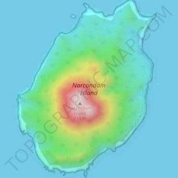
Name: Narcondam Island topographic map, elevation, terrain.
Location: Narcondam Island, Îles Andaman-et-Nicobar, Inde (13.42966 94.24912 13.46474 94.27732)
Average elevation: 115 m
Minimum elevation: 0 m
Maximum elevation: 708 m
Other topographic maps
Click on a map to view its topography, its elevation and its terrain.
Long Island
Inde > Îles Andaman-et-Nicobar > Rangat
Long Island, Rangat, North and Middle Andaman District, Îles Andaman-et-Nicobar, Inde
Average elevation: 11 m
Ile Andaman du Sud
Inde > Îles Andaman-et-Nicobar > Ferrargunj
Ile Andaman du Sud, Ferrargunj, South Andaman District, Îles Andaman-et-Nicobar, Inde
Average elevation: 13 m
Port Blair
Inde > Îles Andaman-et-Nicobar > Port Blair > Port Blair
Port Blair, South Andaman, Îles Andaman-et-Nicobar, 744101, Inde
Average elevation: 27 m
Île Andaman du Nord
Inde > Îles Andaman-et-Nicobar
Île Andaman du Nord, Îles Andaman-et-Nicobar, Inde
Average elevation: 12 m