
Thank you for supporting this site ❤️
Make a donation
Make a donation
Gear up for your next adventure:
As an Amazon Associate, this site earns from qualifying purchases at no extra cost to you.
Serra do Lima topographic map
Click on the map to display elevation.
Thank you for supporting this site ❤️
Make a donation
Make a donation
Gear up for your next adventure:
As an Amazon Associate, this site earns from qualifying purchases at no extra cost to you.
Serra do Lima
Serra do Lima ou como é conhecida Serra de Patu é uma serra localizada no município de Patu no estado Rio Grande do Norte. Tem extensão média de 8 km e sua altitude varia entre 400 e 600 metros.
Thank you for supporting this site ❤️
Make a donation
Make a donation
Gear up for your next adventure:
As an Amazon Associate, this site earns from qualifying purchases at no extra cost to you.
About this map
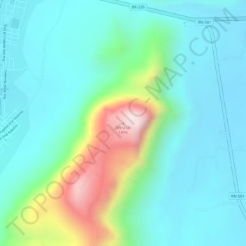
Name: Serra do Lima topographic map, elevation, terrain.
Average elevation: 328 m
Minimum elevation: 206 m
Maximum elevation: 699 m
Thank you for supporting this site ❤️
Make a donation
Make a donation
Gear up for your next adventure:
As an Amazon Associate, this site earns from qualifying purchases at no extra cost to you.