
Make a donation
Gear up for your next adventure:
As an Amazon Associate, this site earns from qualifying purchases at no extra cost to you.
Höfer topographic map
Click on the map to display elevation.
Make a donation
Gear up for your next adventure:
As an Amazon Associate, this site earns from qualifying purchases at no extra cost to you.
Höfer
Zu den sieben Ortschaften gehören die Ortsteile und Siedlungen: Aschauteiche | Aschenberg | Burghorn | Habighorster Höhe | Heeseloh | Kragen | Marinesiedlung | Ohe | Queloh | Rebberlah | Schelploh | Starkshorn | Weyhausen
Make a donation
Gear up for your next adventure:
As an Amazon Associate, this site earns from qualifying purchases at no extra cost to you.
About this map
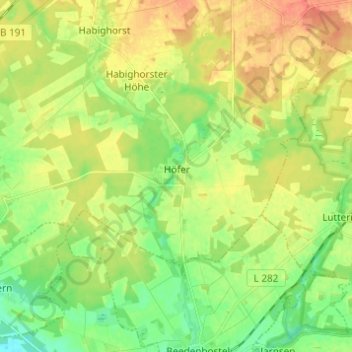
Name: Höfer topographic map, elevation, terrain.
Average elevation: 65 m
Minimum elevation: 44 m
Maximum elevation: 88 m
Make a donation
Gear up for your next adventure:
As an Amazon Associate, this site earns from qualifying purchases at no extra cost to you.
Other topographic maps
Click on a map to view its topography, its elevation and its terrain.
Dalle
Deutschland > Niedersachsen > Landkreis Celle > Eschede
Zu den sieben Ortschaften gehören die Ortsteile und Siedlungen: Aschauteiche | Aschenberg | Burghorn | Habighorster Höhe | Heeseloh | Kragen | Marinesiedlung | Ohe | Queloh | Rebberlah | Schelploh | Starkshorn | Weyhausen
Average elevation: 88 m