
Make a donation
Gear up for your next adventure:
As an Amazon Associate, this site earns from qualifying purchases at no extra cost to you.
Newmarket topographic map
Click on the map to display elevation.
Make a donation
Gear up for your next adventure:
As an Amazon Associate, this site earns from qualifying purchases at no extra cost to you.
Newmarket
According to the United States Census Bureau, the town has a total area of 14.2 square miles (36.7 km2), of which 12.6 square miles (32.6 km2) are land and 1.6 square miles (4.1 km2) are water, comprising 11.24% of the town. Situated beside Great Bay, Newmarket is drained by the Lamprey River and its tributary, the Piscassic River. The town's highest point is the summit of Bald Hill, at 281 feet (86 m) above sea level, near the town's southwest corner. Great Hill, with an elevation of 228 feet (69 m), rises just south of the town center.
Make a donation
Gear up for your next adventure:
As an Amazon Associate, this site earns from qualifying purchases at no extra cost to you.
About this map
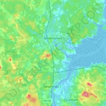
Name: Newmarket topographic map, elevation, terrain.
Average elevation: 21 m
Minimum elevation: -8 m
Maximum elevation: 85 m
Make a donation
Gear up for your next adventure:
As an Amazon Associate, this site earns from qualifying purchases at no extra cost to you.