Geolocate

Teixeiro topographic map

Click on the map to display elevation.

About this map

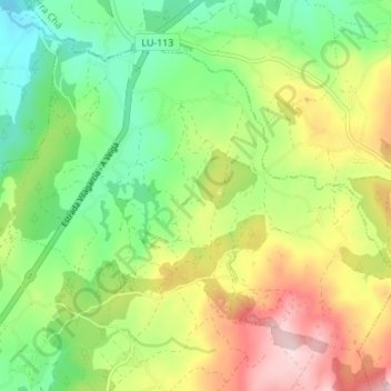
Name: Teixeiro topographic map, elevation, terrain.

Location: Teixeiro, Lugo, Galicia, Spain (43.05857 -7.49964 43.09872 -7.43096)

Average elevation: 526 m

Minimum elevation: 412 m

Maximum elevation: 694 m

Gear up for your next adventure:

🥾Trail Running Boots - Durable shoes designed for trail running
🧢Sun Protection Cap - Breathable cap to protect from sun exposure
🏃Hydration Running Vest - Carry water and maps close to your body for speed
💧Collapsible Water Bottle - Space-saving water bottle for outdoor activities
🧰Emergency Multi-Tool - Compact multi-tool for outdoor survival

As an Amazon Associate, this site earns from qualifying purchases at no extra cost to you.