Geolocate

Valdieri topographic map

Click on the map to display elevation.

About this map

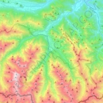
Name: Valdieri topographic map, elevation, terrain.

Location: Valdieri, Cuneo, Piemont, Italy (44.14077 7.18860 44.30969 7.45377)

Average elevation: 1,580 m

Minimum elevation: 623 m

Maximum elevation: 3,262 m

Gear up for your next adventure:

🧦Thermal Socks - Warm socks for winter hiking or camping
Camping Tent - Weather-resistant tents suitable for 2 to 6 people
💡LED Camping Lantern - Illuminate your campsite with long-lasting lanterns
👟Leg Gaiters - Keep debris, mud, and snow out of your boots
Lightweight Backpacking Tent - Compact tent for efficient hiking trips

As an Amazon Associate, this site earns from qualifying purchases at no extra cost to you.