Geolocate

Crane topographic map

Click on the map to display elevation.

About this map

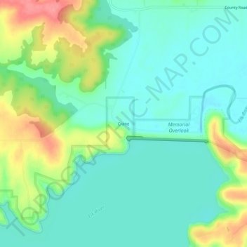
Name: Crane topographic map, elevation, terrain.

Location: Crane, Montgomery County, Kansas, United States (37.25951 -95.81693 37.29951 -95.77693)

Average elevation: 255 m

Minimum elevation: 229 m

Maximum elevation: 314 m

Other topographic maps

Click on a map to view its topography, its elevation and its terrain.

Coffeyville

United States > Kansas > Montgomery County

Average elevation: 229 m

Elk City

United States > Kansas > Montgomery County

Average elevation: 255 m

Independence

United States > Kansas > Montgomery County

Average elevation: 245 m

Caney

United States > Kansas > Montgomery County

Average elevation: 231 m

Gear up for your next adventure:

🦯Trekking Poles - Reduced impact on joints for steep topographic climbs
🧼Travel Hand Sanitizer - Keep hands clean when water is scarce
🥾Trekking Boots - Durable boots for long-distance trekking
💧Hydration Pack - Hands-free hydration system for long hikes
🐕Hiking Dog Pack - Let your canine companion carry their own water and food

As an Amazon Associate, this site earns from qualifying purchases at no extra cost to you.