Geolocate

Lisbon topographic map

Click on the map to display elevation.

About this map

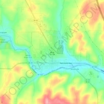
Name: Lisbon topographic map, elevation, terrain.

Location: Lisbon, Columbiana County, Ohio, United States (40.76422 -80.78191 40.78869 -80.72783)

Average elevation: 334 m

Minimum elevation: 278 m

Maximum elevation: 405 m

Other topographic maps

Click on a map to view its topography, its elevation and its terrain.

Negley

United States > Ohio > Columbiana County

Average elevation: 300 m

Valley

United States > Ohio > Columbiana County

Average elevation: 376 m

Valley

United States > Ohio > Columbiana County

Average elevation: 376 m

Gear up for your next adventure:

🧤Insulated Winter Gloves - Heavy-duty protection for sub-zero Canadian adventures
🥾Hiking Leggings - Comfortable leggings for outdoor activities
🥾Trail Running Boots - Durable shoes designed for trail running
🧥Softshell Hiking Jacket - The perfect balance of wind protection and breathability
🧭GPS Tracker - Track your location in remote areas safely

As an Amazon Associate, this site earns from qualifying purchases at no extra cost to you.