Geolocate

Nanjing topographic map

Click on the map to display elevation.

About this map

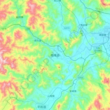
Name: Nanjing topographic map, elevation, terrain.

Location: Nanjing, Nanjing County, Zhangzhou City, Fujian, China (24.35678 117.19239 24.67678 117.51239)

Average elevation: 262 m

Minimum elevation: 6 m

Maximum elevation: 1,043 m

Gear up for your next adventure:

🥘Camping Cookware Set - Compact nesting pots and pans for trail cooking
Bushcraft Tarp - Versatile emergency shelter or gear protection
🔋Lithium AA Batteries - Long-lasting power that performs in extreme cold
Family Camping Tent - Spacious tent suitable for family camping trips
🎒Backpack Rain Cover - External shield to keep your entire pack dry

As an Amazon Associate, this site earns from qualifying purchases at no extra cost to you.