Geolocate

Grants Pass topographic map

Click on the map to display elevation.

About this map

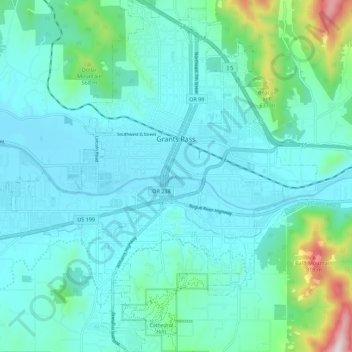
Name: Grants Pass topographic map, elevation, terrain.

Location: Grants Pass, Josephine County, Oregon, United States (42.38969 -123.39400 42.47168 -123.28756)

Average elevation: 374 m

Minimum elevation: 268 m

Maximum elevation: 953 m

Other topographic maps

Click on a map to view its topography, its elevation and its terrain.

Hugo

United States > Oregon > Josephine County

Average elevation: 478 m

Wolf Creek

United States > Oregon > Josephine County

Average elevation: 522 m

Merlin

United States > Oregon > Josephine County

Average elevation: 308 m

Galice

United States > Oregon > Josephine County

Average elevation: 402 m

Williams

United States > Oregon > Josephine County

Average elevation: 484 m

Three Pines

United States > Oregon > Josephine County

Average elevation: 372 m

Lake Selmac

United States > Oregon > Josephine County

Average elevation: 444 m

Murphy

United States > Oregon > Josephine County

Average elevation: 393 m

Wonder

United States > Oregon > Josephine County

Average elevation: 447 m

Provolt

United States > Oregon > Josephine County > Provolt

Average elevation: 394 m

Gear up for your next adventure:

🧰Survival Kit - Essential gear for emergencies in the wilderness
🔦LED Headlamp - Hands-free lighting for early morning starts or late finishes
🥾Hiking Shoes - Durable and comfortable shoes for trail hiking
🎒Fully Waterproof Backpack - Total protection for photography gear and electronics
🥤Collapsible Travel Cup - Saves space and weight in your mess kit

As an Amazon Associate, this site earns from qualifying purchases at no extra cost to you.