Geolocate

Begues topographic map

Click on the map to display elevation.

About this map

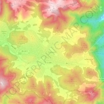
Name: Begues topographic map, elevation, terrain.

Location: Begues, Bajo Llobregat, Barcelona, Cataluña, 08859, España (41.31281 1.90547 41.35281 1.94547)

Average elevation: 409 m

Minimum elevation: 196 m

Maximum elevation: 564 m

Gear up for your next adventure:

🍽️Titanium Camping Spork - Ultralight and indestructible eating utensil
🔥Emergency Fire Starter - Reliable ignition source for all weather conditions
🛏️Sleeping Bag - Warm and compact sleeping bags for outdoor camping
🧢Sun Protection Cap - Breathable cap to protect from sun exposure
🧥Softshell Jacket - Windproof and breathable jacket for hiking

As an Amazon Associate, this site earns from qualifying purchases at no extra cost to you.