
Make a donation
Gear up for your next adventure:
As an Amazon Associate, this site earns from qualifying purchases at no extra cost to you.
Escuintla topographic map
Click on the map to display elevation.
Make a donation
Gear up for your next adventure:
As an Amazon Associate, this site earns from qualifying purchases at no extra cost to you.
About this map
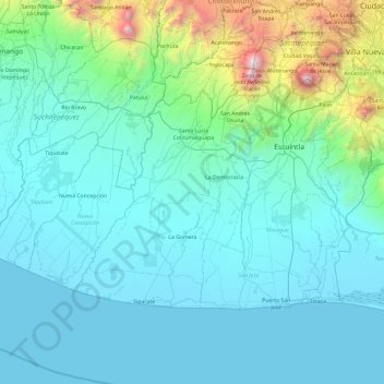
Name: Escuintla topographic map, elevation, terrain.
Location: Escuintla, Guatemala (13.90964 -91.53566 14.47462 -90.58137)
Average elevation: 436 m
Minimum elevation: -1 m
Maximum elevation: 3,951 m
Make a donation
Gear up for your next adventure:
As an Amazon Associate, this site earns from qualifying purchases at no extra cost to you.
Other topographic maps
Click on a map to view its topography, its elevation and its terrain.
Pacaya
Guatemala > Escuintla > San Vicente Pacaya > San Vicente Pacaya > El Cedro
Average elevation: 2,074 m
Make a donation
Gear up for your next adventure:
As an Amazon Associate, this site earns from qualifying purchases at no extra cost to you.