
Make a donation
Gear up for your next adventure:
As an Amazon Associate, this site earns from qualifying purchases at no extra cost to you.
Città di Castello topographic map
Click on the map to display elevation.
Make a donation
Gear up for your next adventure:
As an Amazon Associate, this site earns from qualifying purchases at no extra cost to you.
About this map
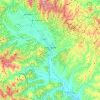
Name: Città di Castello topographic map, elevation, terrain.
Location: Città di Castello, Perugia, Umbria, Italy (43.28135 12.07278 43.61734 12.43482)
Average elevation: 504 m
Minimum elevation: 230 m
Maximum elevation: 1,213 m
Make a donation
Gear up for your next adventure:
As an Amazon Associate, this site earns from qualifying purchases at no extra cost to you.
Other topographic maps
Click on a map to view its topography, its elevation and its terrain.
San Leo Bastia
Italy > Umbria > Perugia > Città di Castello
San Leo Bastia is a frazione of the comune of Città di Castello in the Province of Perugia, Umbria, central Italy. It stands at an elevation of 320 metres above sea level. At the time of the Istat census of 2001 it had 213 inhabitants.
Average elevation: 404 m