
Make a donation
Gear up for your next adventure:
As an Amazon Associate, this site earns from qualifying purchases at no extra cost to you.
Sana'a topographic map
Click on the map to display elevation.
Make a donation
Gear up for your next adventure:
As an Amazon Associate, this site earns from qualifying purchases at no extra cost to you.
Sana'a
Sanaa, officially the Sanaa Municipality, is the de jure capital and largest city of Yemen. The city is the capital of the Sanaa Governorate, but is not part of the governorate, as it forms a separate administrative unit. At an elevation of 2,300 metres (7,500 ft), Sanaa is one of the highest capital cities in the world and is next to the Sarawat Mountains of Jabal An-Nabi Shu'ayb and Jabal Tiyal, considered to be the highest mountains in the Arabian Peninsula and one of the highest in the Middle East.
Make a donation
Gear up for your next adventure:
As an Amazon Associate, this site earns from qualifying purchases at no extra cost to you.
About this map
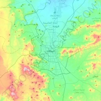
Name: Sana'a topographic map, elevation, terrain.
Average elevation: 2,443 m
Minimum elevation: 2,172 m
Maximum elevation: 3,193 m
Make a donation
Gear up for your next adventure:
As an Amazon Associate, this site earns from qualifying purchases at no extra cost to you.
Other topographic maps
Click on a map to view its topography, its elevation and its terrain.