
Thank you for supporting this site ❤️
Make a donation
Make a donation
Gear up for your next adventure:
As an Amazon Associate, this site earns from qualifying purchases at no extra cost to you.
Merzenich topographic map
Click on the map to display elevation.
Thank you for supporting this site ❤️
Make a donation
Make a donation
Gear up for your next adventure:
As an Amazon Associate, this site earns from qualifying purchases at no extra cost to you.
About this map
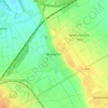
Name: Merzenich topographic map, elevation, terrain.
Location: Merzenich, Kreis Düren, Nordrhein-Westfalen, 52399, Deutschland (50.80813 6.50451 50.84813 6.54451)
Average elevation: 130 m
Minimum elevation: 115 m
Maximum elevation: 148 m
Thank you for supporting this site ❤️
Make a donation
Make a donation
Gear up for your next adventure:
As an Amazon Associate, this site earns from qualifying purchases at no extra cost to you.