Geolocate

Crown Point topographic map

Click on the map to display elevation.

About this map
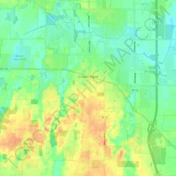
Name: Crown Point topographic map, elevation, terrain.

Location: Crown Point, Center Township, Lake County, Indiana, 46307, United States (41.36921 -87.39758 41.45373 -87.29672)

Average elevation: 220 m

Minimum elevation: 204 m

Maximum elevation: 240 m

Other topographic maps

Click on a map to view its topography, its elevation and its terrain.
Cook

United States > Indiana > Lake County > Cedar Lake

Average elevation: 222 m

Ross

United States > Indiana > Lake County

Average elevation: 194 m

Miller

United States > Indiana > Lake County > Gary > Miller

Average elevation: 186 m

Lake Seven

United States > Indiana > Lake County > Crown Point

Average elevation: 220 m

Liverpool

United States > Indiana > Lake County > Lake Station

Average elevation: 191 m

Triangle Parkway

United States > Indiana > Lake County > Hammond

Average elevation: 184 m

Illinoi

United States > Indiana > Lake County

Average elevation: 192 m

Glen Park

United States > Indiana > Lake County > Gary

Average elevation: 193 m

Gear up for your next adventure:

🧭GPS Handheld Device - Reliable GPS navigation for outdoor adventures
🧴Outdoor Sunscreen - High SPF protection for high-altitude UV exposure
🧥Insulated Jacket - Keep warm in cold outdoor conditions
🔦LED Headtorch - Bright and durable light for night activities
🕯️Camping Lantern - Illuminates your entire campsite with high-efficiency LEDs

As an Amazon Associate, this site earns from qualifying purchases at no extra cost to you.