Geolocate

Olney topographic map

Click on the map to display elevation.

About this map

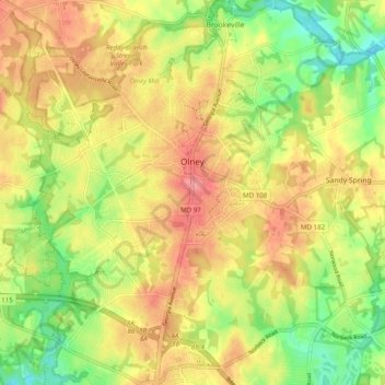
Name: Olney topographic map, elevation, terrain.

Location: Olney, Montgomery County, Maryland, United States (39.10895 -77.11047 39.18515 -77.02751)

Average elevation: 136 m

Minimum elevation: 90 m

Maximum elevation: 175 m

Other topographic maps

Click on a map to view its topography, its elevation and its terrain.

Gear up for your next adventure:

🎒Fully Waterproof Backpack - Total protection for photography gear and electronics
🧢Sun Hat - Wide-brim hat for sun protection
🧤Thermal Hiking Gloves - Grip-enhanced gloves for cold-weather altitude trekking
🥾Hiking Shoes - Durable and comfortable shoes for trail hiking
🔥Camping Stove - Portable stoves to cook outdoors with ease

As an Amazon Associate, this site earns from qualifying purchases at no extra cost to you.