
Thank you for supporting this site ❤️
Make a donation
Make a donation
Gear up for your next adventure:
As an Amazon Associate, this site earns from qualifying purchases at no extra cost to you.
Brahmapur topographic map
Click on the map to display elevation.
Thank you for supporting this site ❤️
Make a donation
Make a donation
Gear up for your next adventure:
As an Amazon Associate, this site earns from qualifying purchases at no extra cost to you.
About this map
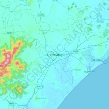
Name: Brahmapur topographic map, elevation, terrain.
Location: Brahmapur, Rangeilunda, Ganjam, Odisha, 760001, India (19.14981 84.63716 19.46981 84.95716)
Average elevation: 56 m
Minimum elevation: 0 m
Maximum elevation: 861 m
Thank you for supporting this site ❤️
Make a donation
Make a donation
Gear up for your next adventure:
As an Amazon Associate, this site earns from qualifying purchases at no extra cost to you.