Geolocate

Teixeira topographic map

Click on the map to display elevation.

About this map

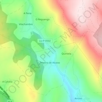
Name: Teixeira topographic map, elevation, terrain.

Location: Teixeira, Baralla, Ancares, Lugo, Galicia, 27687, España (42.90523 -7.27717 42.92881 -7.25049)

Average elevation: 688 m

Minimum elevation: 502 m

Maximum elevation: 914 m

Other topographic maps

Click on a map to view its topography, its elevation and its terrain.

Recesende

España > Galicia > Ancares > Baralla

Average elevation: 638 m

Costantín de Abaixo

España > Galicia > Ancares > Baralla

Average elevation: 609 m

Gear up for your next adventure:

🥾Light Hiking Boots - Lightweight and comfortable boots for day hikes
🥘Camping Cookware Set - Compact nesting pots and pans for trail cooking
🔋Emergency Crank Radio - Weather alerts and power without needing batteries
🕶️Polarized Sunglasses - Protect your eyes with durable polarized lenses
🧢Hiking Hat - Sun-protective and breathable hats for long treks

As an Amazon Associate, this site earns from qualifying purchases at no extra cost to you.