
Make a donation
Gear up for your next adventure:
As an Amazon Associate, this site earns from qualifying purchases at no extra cost to you.
Ravensberg topographic map
Click on the map to display elevation.
Make a donation
Gear up for your next adventure:
As an Amazon Associate, this site earns from qualifying purchases at no extra cost to you.
Ravensberg
Der Blick reicht besonders weit nach Südosten (Goldene Aue, Kyffhäuser mit Kyffhäuserdenkmal, Windleite), Süden (Hainleite, Ohm, Dün) und Südwesten (Untereichsfeld mit Goldener Mark, Dün, Göttinger Wald, Hoher Meissner, Kaufunger Wald, Solling), wogegen die folgenden höher gelegenen Berge im Nordharz eine größere Weitsicht behindern, dazu gehören der Brocken, Wurmberg, Stöberhai und im Nordwesten der besonders niederschlagsreiche Höhenzug Auf dem Acker.
Make a donation
Gear up for your next adventure:
As an Amazon Associate, this site earns from qualifying purchases at no extra cost to you.
About this map
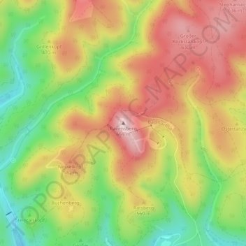
Name: Ravensberg topographic map, elevation, terrain.
Average elevation: 519 m
Minimum elevation: 372 m
Maximum elevation: 652 m
Make a donation
Gear up for your next adventure:
As an Amazon Associate, this site earns from qualifying purchases at no extra cost to you.
Other topographic maps
Click on a map to view its topography, its elevation and its terrain.