Geolocate

Pumpenberg topographic map

Click on the map to display elevation.

About this map

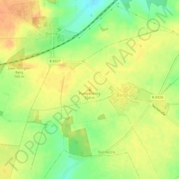
Name: Pumpenberg topographic map, elevation, terrain.

Location: Pumpenberg, Bad Belzig, Potsdam-Mittelmark, Brandenburg, Deutschland (52.10323 12.54525 52.10333 12.54535)

Average elevation: 146 m

Minimum elevation: 123 m

Maximum elevation: 161 m

Other topographic maps

Click on a map to view its topography, its elevation and its terrain.

14806

Deutschland > Brandenburg > Potsdam-Mittelmark > Bad Belzig

Average elevation: 125 m

Lütte

Deutschland > Brandenburg > Potsdam-Mittelmark > Bad Belzig

Ein typisches Bild der sandigen, sanften Hügelwellen im Naturpark Hoher Fläming und seiner lichten Eichen-Kiefernmischwälder, die auf den niederschlagsreicheren Höhen von Buchenwäldern ergänzt werden, vermittelt der Weg von Lütte (ca. 45 Meter über NN) hinauf zum 118 Meter hohen Galgenberg. Der Berg…

Average elevation: 67 m

Gear up for your next adventure:

🥾Waterproof Hiking Boots - Essential footwear for rugged terrain and wet Canadian trails
👖Convertible Hiking Pants - Zip-off legs to adapt to changing weather conditions
🛁Quick-Dry Microfiber Towel - Space-saving towel that dries rapidly on the move
🧣Evaporative Cooling Towel - Beat the heat during intense summer climbs
🧤Rechargeable Heated Gloves - Extreme warmth for Canadian winter expeditions

As an Amazon Associate, this site earns from qualifying purchases at no extra cost to you.